Friday, June 26, 2020

Always Check For Ticks

One thing I have learned living on the east side of the Cascades is when in tick country, you need to check for them thoroughly. I just had an absolutely horrifying experience at the Toppenish National Wildlife Refuge. 

It's a flat 2-ish mile hike. I never did find a good map, but once you are there you can follow the signs that will lead you in a loop out past the maintenance shed. The "trail" is basically a wide road mowed in the field. There is tall lush grass in the riparian lands around it, but I felt pretty confident I was safe as I was walking in the middle of the wide cleared path.

Then I got home and was doing some training with my dog in the yard, and discovered a tick on my shirt. Then another one. Then inside I found one on my neck. I went out to my roommate and asked "are there any more on my neck?" They were like "um...yeah" and picked on off my bra strap.

Cue me running back into my room and stripping down where I found one in my sock and two more in my bra. I was screaming as I went into the shower!

I thought I had them all. I went over to my boyfriend's house and while we were cuddling I ran my hands through my hair....and found four more on my scalp!

EWW! EWWW! EWWWWWW!


I don't know how they got up on my torso/head area as I was only walking through low grass but alas, use my horror story as a warning. In hindsight I think some bug spray would have helped. (My old bottle exploded/expired and I have neglected to replace it yet.)

The best thing to do in tick country is to do a tick check before you head home. Which I apparently did not do diligently enough.

I was lucky that none of the ticks on me had embedded yet. If they do, you want to use tweezers to apply firm pressure but don't squeeze! You don't want the tick to throw up in the wound as it could be carrying pathogens like Lyme disease.

Try to save the tick in a small sealed container like a pill bottle if it embeds so you have it for the doc if you need to go in. If you catch it in the first 24 hours, your chances of getting Lyme disease are slim. Keep an eye out for a classic "bullseye" rash and if you see it get to urgent care...that's a big clue you might have gotten Lyme disease!

The ticks I found on me were dog ticks, which don't carry Lyme. In Washington State, black-legged ticks are the Lyme disease carriers (though it's uncommon...0-7 cases are believed to originate in our state each year). While the ticks that were on me aren't known to carry Lyme, they can carry other nasty stuff, most notably Rocky Mountain Spotted Fever. Fortunately in Washington State, only 0-3 cases are reported each year, so my risk was minimal. 

Even if the risk is low, ticks are still just GROSS! So check yourself before you wreck yourself! Or your roommate will have to put up with your screams coming from the shower!

If you'll excuse me, I need to go burn all my hiking gear now...


Tuesday, October 8, 2019

LNT Seventh Principle: Be Respectful of Other Visitors

Honestly, this principle is the entire reason I wanted to do this series, so this post will probably be the longest. On every hiking forum I am on, I see so many arguments that really center around being respectful of others (or not) that I feel we need a lesson on it.

Who has the right-of-way on the trail?

Just as the rules of the road dictate right-of-way for vehicle traffic, there are guidelines for right-of-way for trail traffic.

  • Downhill traffic should yield to uphill traffic. This is to avoid disturbing the momentum an uphill hiker has carefully cultivated and needs to maintain.
  • Mountain bikers should yield to both hikers and to equestrians/pack animals.
  • Hikers should yield to equestrians and other pack animals.
Some uphill hikers may choose to step out of the way to let downhill hikers past. This is their prerogative. Unless you see them giving up their space, try to follow the guidelines to avoid a faux pas.

The sound of music

If you want your post to be locked down by an admin in any hiking forum, bring up music. The hiking world is clearly divided on this one.

Generally I hike without music, but I've been known to pull out headphones a time or two so I completely get it. Music can make a steep climb go by easier. I don't use a Bluetooth speaker though because I know others probably don't want to hear my music. However, headphones present a safety issue, and sometimes the speaker is a safer option. 

So here is my suggested compromise: on the trail when you're passing people in transit, a Bluetooth speaker is OK as long as you keep the volume to within 20-30 foot audible radius. You're just passing someone for a few seconds and then you aren't disturbing other hikers, so I think it's perfectly acceptable. Once you reach your summit vista or wherever people are congregating for a prolonged amount of time, put the speaker away and let everyone enjoy their experience without your soundtrack. Please, we neither need nor want it. 

I will give one notable exception to the Musical Mountaineers or anyone else who wants to go through the trouble of lugging musical instruments into the backcountry for a live music performance. If you want to put in that amount of effort, then you get to reap your reward! Live music is a go any time. It's a unique experience to add whimsy to an adventure, and I am 100% down with that!

Stop the gatekeeping

There is a massive issue with gatekeeping in the hiking community right now. Hiking is experiencing a renaissance largely fueled by Instagram and other social media. Hipster hikers who were in the backcountry "before it was cool" will share their opinions on who should...and who should not...be allowed in the wilderness, and we need to talk about why this is a problem. 

Public lands belong to the public. That means everyone gets their share at using public lands. This means that hikers need to learn to share with mountain bikers, hunters, ATV users, dogs, equestrians, etc. I have heard all of these groups bashed in hiking forums as not belonging on the trails. The woods are large, and there's room enough for all, so why the hate?

Some Leave No Trace purists feel that leaving any impact on wild lands should not be permitted. The way they talk, we should just wrap the backcountry in giant bubble and not let anyone in! Well, except for them of course, because they have dubbed themselves worthy. Give me a freaking break! I have this crazy, novel idea: we can have spaces for natural wilderness conservation AND still provide a variety of recreation options on public lands! 

Look, the truth is that funding for public lands is on the decline even as the number of visitors steadily climbs. The more visitors are welcomed into outdoor spaces, the greater awareness can be spread and the easier it will be to fight for funding to maintain these spaces. So instead of bashing people with an elitist, holier-than-thou attitude, try some education. That's what I'm trying to do with this series of posts. I'm trying to keep the door open.

Leave No Trace is about minimizing impact in order to allow space for everyone to enjoy the outdoors. Whether you're a mountain biker, an ATV user, a rock climber, a day hiker or a multi-day backpacker, there's room for you. Be considerate of your impact and of others, and we can all get along.

Just be considerate

Really, that's all that LNT boils down to. Be considerate to land managers, considerate to nature, considerate to others, and considerate to your own needs. If you can follow that, then you don't need to memorize seven principles. Just be considerate.

Thursday, October 3, 2019

LNT Sixth Principle: Respect Wildlife

When you're hiking in the backcountry, it's important to remember that all the critters out there consider it their home and you are the guest. In order to preserve the ecosystem, you better respect them. This goes for your safety and theirs.

Don't feed the wildlife

This should be common sense, but you should avoid feeding the wildlife either intentionally or unintentionally.

If animals become too reliant on people for food, this can interfere with their natural migration patterns and their ability to survive harsher months. Depending on what you're feeding them, it could be ultimately unhealthy for them. Also, lots of the adorable little alpine mammals can carry hantavirus, which while rare is very unpleasant if you're unfortunate to contract it. The symptoms range from fatigue and muscle aches to nausea, abdominal pain, and respiratory distress.

Look, I get it, they're cute and you want to lure them in for a picture, but it's just not good for them. If you must feed animals, stick to the birds at an urban municipal park (but feed them seeds, not bread).

In addition to not feeding the animals intentionally, it's important not to feed them unintentionally either. I am specifically considering bears here. Bears are very, very food motivated. The day they associate humans with food is a bad day for the bear; if they become a nuisance or become aggressive it is highly likely that animal control will put the bear down. Relocating doesn't work; a bear associating people with food is too dangerous for people and will be killed. Keep food in a bear canister or hanging up on a line, and keep that food at least 100 feet from wherever you are camping. Some regions require bear canisters while backpacking, so check the regulations where you are going.

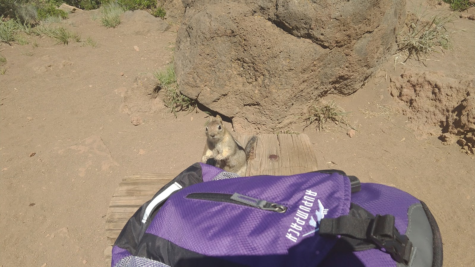
This little golden mantled squirrel thinks all people = food, and boldly approaches my pack while I'm resting.


Give them space

Speaking of bears, don't approach them! Or any alpha predator for that matter. I mean, they could eat you! If you get too close and stress them out, their "fight or flight" instinct could kick in and if they choose fight, you probably won't come out ahead. So many, many times I hear about people who saw a cute little baby bear and were like "daww, let's get closer for a picture!" only to be mauled when Mama Bear came charging. Don't approach them!

Exact distances may vary by land manager (Yellowstone has specific rules to stay 25 yards away from large wildlife, for instance), but for large predators 100 yards (1 football field) is a good rule of thumb.

In fact, you can use your "rule of thumb" to measure if you're too close: Hold your arm straight out and stick up your thumb. If you can completely obscure the animal with your thumb, you are a safe distance away. If not, then you're too close and should back away when reasonable. Sometimes the animals have other plans, but don't move yourself closer.

Don't interfere with their environment

Avoid camping within 100' of lakes or streams to avoid cutting wildlife off from water sources (some land managers require a 200' buffer zone).

Also, consider putting the Bluetooth speaker away. I'll talk more about that in the next post, but making too much noise can disrupt wildlife. A little noise is fine to ward of predators; bells or just talking to your hiking companions is typically more than enough. Consider your noise impacts when hiking. The quieter you are, the more wildlife you are likely to see, no food lures required!

Sunday, September 22, 2019

LNT Fifth Principle: Minimize Campfire Impacts

In recent decades, the number and size of wildfires has been steadily increasing. While several factors can start a fire, you can avoid becoming one of those factors by following the fifth principle of LNT: minimize campfire impacts. Not only can you avoid starting a wildfire, but you can also protect the environment from impact and invasive species.

The first thing you think of is preventing wildfires.

It's hard not to with this principle with all the recent major wildfires. So we'll start here.

The first thing you need to consider is, should you even build a fire? Check the fire risk before you head out and find out if there are any burn bans. You might be able to get by with just a camp stove as a safer option.

When building a fire, try to use an existing fire ring. Mound fires or fire pans are also options for containing your fire. Burn everything to white ash, soak with water, and scatter. Feel the ashes to make sure they're cool before you leave them; on many hiking forums I see multiple pictures each year from people who discovered smoldering ashes left behind and had to scramble to put them out before a large fire started.

This principle is about more than fire prevention.

Remember, LNT is all about minimizing our impact overall, so we have a few other things to consider.

If you're in the backcountry, make sure you aren't building your fire over delicate flora. Harvest firewood in a dispersed manner to minimize your impact, and if you're in a high alpine or a desert environment be mindful if there's sustainable firewood available for harvest. Once your fire is out completely, disperse your impact so the next person wandering through won't be able to tell there was ever a fire there. If there are established fire rings, use them instead of building your own.


Don't move firewood.

Many states have laws that prevent bringing firewood across state lines. This is to prevent the spread of invasive species that might be hitching a ride in the firewood. A pest that would likely be limited to a small area can travel hundreds of miles via firewood, causing a fresh outbreak.

If you buy sealed firewood with a USDA APHIS heat treatment seal, you're generally good to transport it as long as it stays sealed until you get to your destination (important note: this is not the same as a "kiln-dried" label). Otherwise, look to either forage your own or purchase firewood locally, preferably within 10 miles of your intended campfire when possible.

Wednesday, September 18, 2019

LNT Fourth Principle: Leave what you find

Every year, the headquarters of Hawaii Volcanoes National Park is flooded with mail containing sand, rocks, and other artifacts tourists collected from the park. The volcanic rocks are interesting and tempting to take, but according to the mythology of "Pele's Curse", bad luck will befall anyone who removes objects from the island. Hapless tourists have been hit with strings of bad luck after chancing removing a rock, and many try to break the curse by returning what they took via the US mail system.

Not every place has a curse, but it's important to always keep in mind Leave No Trace's fourth principle: Leave what you find. The scope of this principle is interesting and isn't exactly what you think, so let's take a closer look.

What are we finding and leaving?

There is a certain about of judgement we need to use with this principle. What we want to do is leave the natural environment more or less how we found it. This means no digging trenches around tent sites, no hammering nails into trees to hang your hammock, no picking delicate trillium flowers, etc.

However, it also means we need to leave some impacts. A fire ring at a dispersed campsite is not a natural phenomenon, but if we dismantle it, it will just be rebuilt, so it's better to use it and leave it. Cairns should not be randomly built just for the glee of it, but we also should be leaving pre-established trailmarker cairns so other hikers can locate and stay on the trail.

Cultural artifacts also should be left alone. The Archaeological Resources and Protection Act protect these artifacts and removing items like pot shards or arrowheads is actually illegal. Plus, if you take them then other visitors won't be able to enjoy them.

We don't want to add anything either.

I was recently in Lave River Cave near Bend, OR, and I had to plan my outfit carefully to avoid introducing a fungus that causes White-Noise Syndrome to the local bat population. Everything I wore into that cave could not have been used in another cave, and now I can never take that gear into a different cave again, as the fungus has a 100% mortality rate.

Part of leaving the environment the way you found it means not introducing any invasive species or pests. Make sure you regularly clean your hiking boots to avoid spreading seeds, be very aware of caves and what gear you're bringing into which cave, and don't move firewood beyond local regions are all methods to avoid adding unwanted contaminants to wild areas.

Exploring a cave, but being mindful of the health of the bats while doing it
Are we really not allowed to take anything at all?

"But what about people who forage for berries?" you might be protesting. "What about the mushroomers?" Be cool, man. There are cases where we can forage on public lands. These include foraging for berries, mushrooms, rockhounding, and even firewood or Christmas trees. Typically, it's illegal in national parks and wilderness areas but allowed on BLM or national forest lands. Often, there are foraging limits and/or special permits needed, so check with the land manager before you head out.

The most important thing is to consider the impact you are having, and make sure that while foraging you are minimizing your impact and only taking what you need. Will you have to trample delicate alpine grasses to get to that huckleberry patch, or is there another more accessible patch you can forage from with less impact? Foraging is fine as long as you're responsible and conscientious about it!

Wednesday, September 11, 2019

LNT Third Principle: Dispose of Waste Properly

Don't litter. Pack it in, pack it out. Take only pictures and leave only footprints. That's probably the first thing people think of when they consider "Leave No Trace." We're taught before we even start school that littering is wrong, and how to use a trash can. However, some people still seem to struggle with this concept. I often pick up at least one piece of waste each time I head out. When I went to Boulder Cave, it was mere days after opening and I ran into trash everywhere...I packed out a whole bag and could have packed out more if I had room.

Pack it in smart to pack it all out

The best way to avoid littering is to avoid bringing in waste to begin with. Look at your food packaging. Is there a way you can reduce it? The less you load your pack with, the less you have to pack out.

We live in a world of water bladders and collapsible water bottles, so consider those options instead of a disposable plastic bottle. Also, consider having a dedicated space in your pack for waste. I try to compress all my trash together to both save space in my pack and to make it easier to clean out later.

If you get to the trailhead and the trash is full? You get to pack it all the way home! Don't cram your junk in an overstuffed trailhead trash bin. This should be common sense, but it's a problem I see all the time. Just take it home and throw it in your own trash bin. Or hit up a rest stop on the way and chuck it in their bin, whatever. Just make sure it ends up securely in the trash and off the trails.

Let's talk about dog poop

I've written about this before, but it serves a brief mention again. Pick up after your dog. Dog poop doesn't decompose the same as wildlife scat, so it needs to come out with you. On a recent hike on Cowiche Mountain, I noticed several piles of hard, dried dog poop trailside that definitely wasn't decomposing quickly. So make a plan to pack it out. I have a dedicated outer pocket on my pack for used dog bags.

Also, can we please stop with the bagging of dog poop and leaving it behind? You're just adding dog feces and plastic litter. It's worse than not bagging it up at all. I don't understand why people do this, and it needs to stop.

Let's talk about human poop

"Dispose of Waste Properly" means all waste, not just bits of paper and plastic litter, so let's talk about it. I've been fortunate enough to not encounter used TP and human feces trailside, but it seems to be a common issue in some areas based on the complaints I read in various hiking forums, so we need to learn how to shit in the woods (that link leads to some suggested reading).

Typically, you can dig a cathole and bury your shit. You'll want to find a space 200' from any water source, and 100' off the trail, and you'll want to dig your hole at least 6 inches deep. Make sure you also stay away from any poisonous plants...you should be staying away anyway but when exposed ass is at stake you want to be extra careful!

You can bury your shit, but you must pack out the TP! Same goes for tampons. A ziplock bag will do; you can double it up for extra peace of mind.

If you're on snow, rocks, in a narrow river canyon, etc., then you'll need to pack your shit out too. Most ranger stations for alpine areas offer "blue bags" to pack it out. You can find "wag" bag systems with absorbent gelling powder to help with sanitation, and it's usually a double-bag set-up. When done properly, you should be able to pack it out without contaminating the rest of your pack.

Whatever you do, don't just leave your shit lying around. No one wants to see your shit. Figure your shit out.

Sunday, September 8, 2019

LNT Second Principle: Travel and Camp on Durable Surfaces

Do you know what's under your feet? It might be more fragile than you think. In alpine meadows, tiny grasses and plants are prone to trampling and can take a long time to heal. In desert environments, cryptobiotic crust aka "living soil" is crucial for containing moisture and is easily damaged by boot prints. Paying attention to what you're hiking or camping on is important to protect maintained trails and the surrounding environment.

What's a durable surface?

Generally, you want to stay on the maintained trail. Trails are designed with the environment in mind including drainage, local flora and fauna, and erosion. Cutting a switchback can lead to erosion and damage not only the environment but the trail itself. Heading into a seasonally closed trail can disturb the wildlife. Stick to open listed trails as much as possible.

When camping, look for surfaces with dirt, rocks, sand, gravel, or snow. Avoid crushing flora, especially in sensitive alpine regions. Most areas prohibit camping near water as human presence can cut off wildlife from their water source, so you want to stay at least 100' away from lakes and streams (LNT.org suggests 200' is even better). If you can use an established backcountry campsite, even better as this is already impacted so you aren't really exacerbating anything.

When you can't avoid vegetation when camping in a pristine site, make sure you try and "fluff" it back when you're all done. Your campsite should look as it did before your arrived; no one should be able to tell you were there!

Car-camping at a developed campground is always a safe bet
What are the exceptions?

Sometimes, you just have to leave the trail, such as when nature calls. When this happens, try to disperse your impact. If you see an area where impacts are forming, avoid it. Walk on solid ground as much as possible, and try to find the path of least impact.

When might you need to head off-trail?

  • To find privacy to relieve yourself
  • To forage for firewood or camping resources
  • To go hunting
If you're with a group, spread out to minimize and disperse your impact in the area.

What are not exceptions?


Come on, don't do it for the 'Gram. Unless you're really, really far in the backcountry, consider what impact that pic is going to have. If everyone else crowds in and takes the same off-trail path, it's going to become eroded and damaged. Promote good trail stewardship on IG and other social media. Let's use some common sense here, please?

Wednesday, September 4, 2019

LNT First Principle: Plan Ahead & Prepare

On September 2nd, 2017, a group of boys playing with fireworks started a fire near Eagle Creek in Oregon along a popular hiking trail. Cut off from the trailhead, 153 hikers found themselves trapped. Most of these hikers were visiting a popular swimming hole at the popular Punchbowl Falls, and many were equipped with little more than flip-flops and swimsuits. They were forced 6 miles upstream where they had to camp on bare ground, huddling together for warmth. Forest Service rangers reached them with  limited emergency supplies and in the morning led them several more miles the next day to safety.

The Eagle Creek Fire scenario is a fortunately unlikely occurrence, but it highlights how things can go terribly wrong even on a seemingly easy and simple hike, and how it pays to be prepared. The hikers were lucky they were able to stay together and all of them got out without serious injury, but it could have ended much worse.

The first principle of Leave No Trace is to Plan Ahead and Prepare.

What does Plan Ahead mean?

Know where you're going, and what regulations are in place. Find out who the land manager(s) are for where your are hiking and understand the rules before you go.

Questions you should be asking (not a complete list):

  • Do I need any permits for my car or person?
  • Is this a wilderness area?
  • (For dog owners) Is my dog allowed?
  • What is the weather forecast?
  • Is it a hunting area and are there hunting seasons I need to know about?
  • Is this trail going to be completely packed and busy when I plan to go?
What does Prepare mean?

If you head out unprepared or underprepared, you are risking not only your own safety but the safety of the Search & Rescue folks who would have to go out and save your butt.

The first thing you should do is tell someone where you are going, when you plan to return, and who to contact if you don't check-in at the pre-appointed time. I'm a solo-hiker, so I always tell someone where I'm going. Often, the location is meaningless to them, but at least they know which ranger station to call and forward my info to in case of emergency, and that info will mean something to the right people should the need arise.

There are multiple lists of "The 10 Essentials", "The 11 Essentials", etc. What you need to pack depends on what sort of hike you are planning on. When choosing what to pack, I always think "what is the worst case scenario that could happen to me?" Usually that's eaten by a bear, so then I think "what's the second worst case scenario?" That often involves getting lost or injured, so I like to pack enough I could overnight at least a night in an emergency. If I'm going into an area where there's lots of people I'm not as concerned, but if I think I might be the only hiker out there I want to have enough to survive for 48 hours. What that looks like will vary depending on where I'm hiking.

Instead of 10 essentials, when packing I like to think food, water, shelter, first aid, and navigation/signalling.

  • Food isn't just my lunch I'm packing; it's granola bars and jerky that are extra in case I need them. (I also have a compact "survival pack" with a fishing hook and line, but I doubt I'm skilled enough to successfully catch anything...hopefully I never have to find out). 
  • Water is dependent on where I'm hiking; if I know I'll have lots of opportunities for refills I won't pack as much. Water purification tablets are good for refills, and I also pack a Lifestraw just in case. The general rule is 2 cups of water for every hour of hiking, but it's good to pack extra if you can afford the weight just in case.
  • Shelter for me is extra clothing, rain gear, and overnight survival. I have emergency ponchos and those silver emergency blankets in my pack along with any extra jackets or layers I deem appropriate as necessary. Hats, sunscreen, bug spray, and other protections from the environment I clump in this category.
  • First aid is a first aid kit with gauze, bandaids, tweezers, and other little essentials. You never plan on getting hurt, but one misstep and a tumble can cut you up or worse. 
  • Navigation/signalling are for finding your way and helping others find you. GPS is nice, but having a map and compass are a good backup for when batteries die. A flashlight (and batteries!) is essential for night travel. Whistles and hi-vis gear will help you be found (a whistle can carry farther than your voice).  A fire-starter of some sort is also helpful, whether it be a lighter or waterproof matches (I've tried to get my sparker to go, but have yet to successfully get a fire going on a test run...if you have that skill then kudos to you).
  • The other miscellaneous things I pack are a multi-tool and a knife, because they're lightweight and you just never know when you might need them. (Just a few weeks ago I packed a sandwich with particularly difficulty packaging and required the multitool to get it open.)
Preparing for car camping trip...getting my essentials together!
Exceptions to the rule

No, there are no exceptions to this principle. Be prepared. Safety should always be you number one priority! No exceptions!

Sunday, September 1, 2019

Leave No Trace - The 7 Principles

So last year I made a pledge to myself to do more to promote "Leave No Trace" principles in my social media posts. Considering I haven't updated this blog in over a year...yeah I kind of fell off the wagon. My life spiraled into a bi of chaos, a bit of laziness, and I just haven't been writing. I'm going to try and fix that.

"Pic for attention" LOL

I've still been hiking, but I've been having difficulty motivating myself to actually write any trip reports or guides, so I'm going to take a dive instead into Leave No Trace principles. Some stuff is research backed and I'll cite my sources, some of it is my opinion, but I'm going to look at each of the seven principles over the next few posts.

What are they, anyway?

According to the Center for Outdoor Ethics, there are seven LNT principles:

  • Plan ahead and prepare
  • Travel and camp on durable surfaces
  • Dispose of waste properly
  • Leave what you find
  • Minimize campfire impacts
  • Respect wildlife
  • Be considerate of other visitors
They're pretty straightforward, and can typically be summed as "use common sense" and "don't be a dick", but in my hiking forums there's a lot of contentious points about some of the LNT principles, especially that last one. You would think that basic principles to help balance preservation with recreation would not cause such an issue, but the various Facebook groups I am in would beg to differ. Those poor admins have locked commenting on countless threads over petty stuff.

So here we go. Over the next few weeks, look ahead as I dive deeper into each one and outline what I believe is acceptable behavior, what is definitely not, and how you can be a good outdoor steward while still getting that awesome Instagram shot. Let's dive down this rabbit hole (but not literally, as we want to respect the wildlife).

PS: I do plan to eventually get back to hiking guides. My life is still a crazy tumultuous tumbleweed right now. I'm using that stress to get these posts churned out, but the light at the end of the tunnel is clearly a glowing neon sign reading "Burnout" so bear with me if I go silent again while I try to bring order to the chaos.

Thursday, July 5, 2018

Endless Switchbacks - Beacon Rock

Do you like switchbacks? This trail has 52 of them, according to the Washington State Parks. I only counted 51 on the way down, but what do I know?

I discovered this hike when I was driving back from Portland along I-84. I looked across the river and saw a lonely, rocky spire. I had to check it out!


Beacon Rock State Park is along the Columbia River gorge, just west of Bonneville Dam. It's a gorgeous area even though across the river is currently scarred from last year's Eagle Creek fire. This hike is short, just a mile to the top, but there's lots of other hikes in the park to choose from to extend your stay.

Beacon Rock
Washington State Parks
Parking permit: Discover pass ($10/day or $30/year)
Distance: 2 miles round-trip
Elevation gain: 600'

Parking is in the state park in a turn-off right off Highway 14. There's a decent privy at the trailhead. Follow the signs to the hiking trail; the other trails you see lead to the technical climbing route.

(Fair warning: if you access it from I-84, the Bridge of the Gods is a $2 toll each way. I did not know this until I got there. They accept plastic, but on my return trip their computer was down so I had to pay with a $20 bill and got all my change in $1s.)

As you climb, you'll zig-zag back and forth along the literally dozens of switchbacks, with amazing views the whole way. There's a commemorative stamp at the summit; I brought nothing to stamp so I used my arm but if you want a souvenir bring a notebook or something. There are a lot of switchbacks. And I mean a lot of switchbacks. It's enough to make you a little...crazy.

In fact, instead of my usual blog writing, I'm just going to give you screenshots of my Facebook feed and let them speak for themselves. Enjoy.


Honestly, this was a really easy hike. Despite the climb, the trail is fairly even. Kids could do this hike. Combine it with other hikes in the park and make a full day trip out of it!

Thursday, June 28, 2018

Hidden Crossings - Umtanum Creek Canyon

This hike has been particularly frustrating for me. It was one of the first hikes I attempted after moving to the Yakima area. My first attempt was in early spring and it was flooded out. My second attempt came a few months later, where about a mile in I found myself stuck, unable to find where the creek crossed.

This year, I met a fellow hiker who had gotten stuck at the same point. We set out together. It took a bit of hunting, but we finally found the creek crossing! We went until we hit another dead-end. If we were feeling bold, we could have attempted another creek crossing but her toddler was ready to turn around at that point. I believe you can go all the way up the canyon to Wenas Road if you are motivated enough, but that would be a significantly longer hike that would likely require overnight camping.

We were just excited to find the crossing! I'll try to explain where we found it as best as we could.

Umtanum Creek Canyon
FBLM/WA State DNR
Parking permit: $5 FBLM permit
Distance: 4 miles round-trip
Elevation gain: 500'
From Ellensberg, head south on Canyon Road until you reach Umtanum Creek Recreation Area. From Yakima, head north on I-82 and take the exit for Highway 821. Head north on 821 through the canyon until you reach Umtanum Creek Rec Area.

You'll cross a blue footbridge across the river and then go under the railroad tracks to reach the trail.


At the obvious noticeboard, there's an obvious trail that goes to the left and up. Ignore that and hang a right instead, heading up the canyon. There's a lot of open steppe interspersed with tree groves. Later in the year, you may be fighting your way through shoulder-high tall grass that obscures the trail, so spring is probably the best season for this hike.


The banks of the creek are often steep on one side, so you can't just cross wherever you please. It took some hunting, but we found the crossing a little bit after the beaver dam.


A bit after this, the trail begins to braid out in multiple directions, with several dispersed campsites dotting the area. Keep to the narrower path closer to the creek and look for where it levels out with a big rocky shore. Here, we found a few logs that seemed intentionally placed to allow crossing. With a bit of careful balancing, we were able to cross and pick up the trail on the other side.

If you don't cross, you'll come across some old fenceposts and markings of an old homestead. If you hit this, you've gone a little bit too far. If the trail dead-ends in a festering pool of green muck, you definitely went too far.

Remember, there aren't too many places you can cross due to the steepness of the creek banks. The crossing is about a mile up the trail, so keep exploring any accessible bank until you find the crossing point. It's there, but it's difficult to find!

We continued on for another mile until we hit a dead end.


At this point if we were ambitious enough we could have made it across...it's shallow enough and there are enough footholds it wouldn't be too challenging, however we didn't see an obvious continuation on the other side, so we decided to turn around here. There are some nice areas to sit and rest in the shade, so it's a decent picnic and turnaround spot.


There were some flowers, though we didn't hit it at peak flower season, and there were lots of birds, snakes, and other wildlife. One squirrel in particular I think we annoyed, as it didn't seem to appreciate sharing the trail and thought we were following it.

As frustrating as this hike was in the past, it felt great to finally find that crossing and push through the other side. Perseverance and determination finally paid off, especially when two hikers worked together.

Thursday, June 21, 2018

Sketchy Bridges - Tieton Nature Trail

I've hiked this trail in two different sections. There are three different creek crossings you may choose from. Two of them are scary, one is not. No matter where you cross, you'll get to enjoy a mix of shade from conifer trees and open shrub-steppe grasslands

Tieton Nature Trail
Washington State DNR
Pass: Discover Pass ($10/day or $30/year)
Distance: ~6 miles round-trip
Elevation gain: negligible
From Yakima, head west on Highway 12. At the junction with Highway 410, turn left to stay on 12. The best place for parking is at the Oak Creek Wildlife Center about half a mile from the junction, on the eastern-most end of the trail. There's a nice metal bridge across the street from the wildlife center you can start at that's very solid with sturdy railing.

Alternatively you can go about 1.5 miles past the wildlife center to a Quonset hut and a suspension bridge; this is where I have parked however the holes in the metal plates required me to carry my dog across as they were too big for his paws.


Be warned that this suspension bridge has a lot of slack in it. And while it looks like there's a handrail there, that's the top cable and you'll have to be tall enough to reach it if you were hoping to hold onto it (on the shore ends, I generally can't reach it with my 5'7" height and have to grab the vertical support bars, but for the bulk of the span I can reach the cable). If you have a group of people I would cross one at a time because of the sway.


If you really don't want to pay for a permit (at $30/year, it's a steal if you're really into hiking, but I digress), there's a limited amount of free parking about 3 miles past the wildlife center, across the street from a slow vehicle turnout. Park across the street; don't park in the turnout! There you'll find a narrow footbridge. It's about two and a half feet wide and there are no handrails which makes it a bit of an unnerving option, but unlike the suspension bridge it's solid underfoot.


Really though, the bridge across the wildlife center is the best. I don't have a photo of it at the moment unfortunately, but it truly is a good solid bridge. If you get nervous around bridges, that's the crossing you definitely want.

Starting from the wildlife center, you'll cross the bridge and immediately head right and go through the wildlife gate. For the first three miles, you'll wander across lots of open steppe. Bring plenty of water in warm weather; you'll need it here.


The trail is mercifully flat, so it's a great hike for a newbie.


You'll pass beneath the Royal Columns, towering basalt cliffs that are a popular spot for rock climbers. Keep in mind there are seasonal closures to protect nesting eagles, however the trail passes just outside the closure area so you're safe for hiking.

From the suspension bridge to the footbridge, you'll encounter more tree cover interspersed with grassy meadow. The trees are not many, but when you're in the thick of it you can almost, almost feel like you're in a real forest. For this native west-sider, it was a breath of fresh air.


The trail will also gain a few slight hills here. In the early spring, I found some mud from recent snow melt, but it was easily navigable.


Beyond the footbridge the trail continues for approximately another mile, though I did not venture out that far.

This trail is best in the spring or fall. In the winter it is snow-covered and snowshoes are a must. In the summer, beware of the high heat. For the shoulder seasons, though, this is a perfect hike that offers a lot of variety in a relatively short distance.

Thursday, May 31, 2018

Rocks and water - Ancient Lakes

Long time no write! I've been busy working two jobs. I've been hiking, just not writing. So here we go for a late start to the hiking season!

Back in February I was single, so I took myself and the dog out for a Valentine's Day hike to coulee country. Winter is the time for desert hiking in my opinion. It's cool and there are no rattlesnakes out!

Ancient Lakes Loop
Washington State Dept. of Fish & Wildlife
Parking permit: Discover Pass ($10/day or $30/year)
Distance: 4.6 miles round-trip
Elevation gain: 278 feet
To get to the trailhead, take I-90 exit 149 if coming from Ellensberg or 151 if coming from Moses Lake, and head north on SR-281. After about 5 miles, turn left onto White Trail Road (Rd 5 NW). Wind through farmlands for 7.8 miles and take a left on Rd 9 NW. After a couple miles and a steep downhill grade, the pavement ends and the road becomes Ancient Lakes Road. Follow the road all the way to the end to the trailhead parking.

Even though there are lakes and waterfalls, most of the water is agricultural run-off from all that farmland you drove past earlier. You'll want to pack all the water you'll need for your hike. The valley is a popular backpacking spot; if you decide to camp overnight, make sure you bring plenty of H2O!

As you can see from the satellite, there are several trails that braid off the "official" trail. I ended up following the northernmost one and dead-ending at the lake, then working my way around until I joined the "official" trail. I don't recommend this. The path I took around the lake dwindled to nothing and ended up costing me a lot of energy to finish navigating. 

Otherwise, it was a beautiful hike. There had been a light dusting of snow the evening before. For most of the hike, the sun stayed behind a cloud and gave off some fantastic lighting.


At the easternmost lake, a waterfall in the distance can be seen. There's another trailhead above that waterfall somewhere, with a hike down the cliff. Someday I'll find that trailhead and hit the valley from that angle.


There's also supposedly a route that leads up the blade that separates this coulee from its next-door neighbor. I think I saw the route but couldn't get to it this time, so next time I'm gonna give it a shot.


In the summer, I imagine the heat is sweltering out here. For a February hike, it was nice and cool. I took off my jacket when I hit the sunny spots.


This is a great off-season hike (just check the road conditions, as there's a steep curve to contend with that I wouldn't want to attempt when icy). I'll definitely be returning to this area to access it from the other trailhead and check out Dusty Lake coulee to the south.