Showing posts with label Deception Pass. Show all posts

Thursday, July 7, 2016

Goose Rock/North Beach - Deception Pass State Park

Long time no post! I've been busy studying for my national board exam, which I just completed yesterday. (I have to wait a week and a half to find out if I passed, though.)

I haven't had much time for hiking, but a few weeks ago I did manage to make it up Goose Rock in Deception Pass State Park. I also hiked along North Beach.

View from the Summit
I went on a sunny June weekend. It was cloudy when I left Bellingham, but the skies were blue by the time I reached Anacortes. The park was fairly full, too, though I still managed to find parking by North Beach.


Playing troll under the bridge
Of course I brought my hiking buddy with me!

Hiking Buddy

Scenic meadow at the top

Apparently, the person with the "Zombie Stryke" backpack with purple fuzzy handcuffs is the perfect person to ask for directions, as I was regularly stopped by people wanting to know how to reach the summit.

Yes, the handcuffs are STILL on the hiking pack
Most of the people asking were approaching the summit from the perimeter trail, which if you ask me is the WRONG direction to go.

Lots of wildflowers! 
Taking the perimeter trail first means you have to climb up a narrower, rockier, steeper route to the top. It is a lovely trail to take; I prefer to take it on the descent though.

Cornet Bay as seen from the perimeter trail
 When we finished our Goose Rock loop, we hiked along North Beach, which offers some nice views of Deception Pass Bridge. I took the beach to the amphitheater and to West Beach. By then, I was running out of steam and my ankle was sore, so I headed back. (My original idea was to hike along West Beach as well.)

Pooch enjoying the sand
Views of the bridge

Taking the trail above the beach back

North Beach Panorama
 At the amphitheater, a park ranger was either setting up or taking down a presentation. She had a trailer with a large whale skull and some whale ribs.

Not sure if real or plastic, though.
At West Beach, the sand is sandier and the view opens up to a bigger ocean. There's a dune trail to the south. There's also a huge parking lot here, though on the weekend even it was mostly full.


I've been recovering from a stubborn ankle injury, and the walk along North Beach exacerbated it. Fortunately it seemed to recover faster than it had on hikes in the past. As it heals, and with my exam behind me, I'm hoping for more hikes in the future!


Thursday, October 22, 2015

Trees and more trees - Hoypus Forest

Long time no post! Due to schedules, weather, and personal life, I have not had much time to hike, let alone post. I finally, finally got a hike in on Sunday, though! I decided to head to Deception Pass to check out a corner of Deception Pass State Park that I'd never visited before.

To get to Hoypus Point Natural Forest Area, turn onto Cornet Bay Road from Hwy 20 (on the Whidbey Island side of the pass) and follow it all the way until the end.

Hoypus Forest Natural Forest Area - Deception Pass State Park
Parking Permit: Discover Pass ($10/day or $30/year)
Distance: 5 miles
Elevation gain: 400'
The parking is right alongside busy docks and a boat ramp. Signs advertise that you can park here for boat tours. I imagine it fills up in the summer, but on this gray and drizzly autumn day it was fairly quiet.


To start off, you'll walk down the road past the gate for about a mile. It's a level and easy hike, with lots of beach access along the way. I encountered a family that had biked down to their favorite beach spot. It seems to be a popular path with the locals.

None shall pass. Except hikers. Hikers are okay.

Along this stretch, you'll get peek-a-boo views of Deception Pass Bridge through the foliage.


At the end of the road is a clearing. A small service road goes up to a storage area, and two trails branch off the end. To get to Hoypus Point, take the left one that hugs the water.


Hoypus Point is a small clearing that opens up to beach. You can see Fidalgo Island to the north. It was pretty misty when I went.


The beach is small but sandy, something uncommon in this region of rocky beaches. It would make a great lunch spot!


Back to the end of the road, take the other trail, which is the East Hoypus Point Trail. Heading into the woods, the trails are fortunately a little more well marked.


There is a decently sized trail system here, so you can mix and match trails to shorten or lengthen your hike as you wish. I plotted out a loop that was five miles including the jaunt out to the point.

There are some amazing trees in here.


This dead tree had a little bit of new growth coming out the top.

Seems like as good as any a spot to take up root.
I was especially fascinated by the fallen giants.

The dog is small, but he looks even smaller here.


There were also lots of mushrooms. I thought these were particularly pretty. I am not a mushroom person though, so not sure what kind they are.


You'll run into the boundary of the park eventually, as well as some residents' backyards, so be respectful. There is a junction with Fireline Trail that will take you back toward the parking lot, but I pressed on for a bit of a longer loop. There are a few unmarked junctions, so when in doubt, hang right. After a brief climb, I turned on the aptly named Hemlock Hideaway.


Then I turned on Forest Grove.


I didn't notice there was a trail named "Slug Slough" when I was initially planning my route, so didn't take this trail, but I wondered if it was as aptly named as the others.


Even though the forest is surrounded by civilization, when you're in the thick of it it's dead quiet and seems to stretch forever.


I rejoined Fireline Trail and then followed the signs back to South Hoypus Point Trailhead to finish off my hike.

The first route I planned out was over 7 miles long when I plotted it out, and you can make even longer routes, so you can spend a fair amount of time exploring these woods. It was a great relaxing getaway for a few hours on Whidbey Island.


I'm not sure how often I'll be able to update here as we go into the winter months. I will see if I can pull photos from old hikes and run with those. I may cut back to updating every other week though. We will see what happens.

Thursday, September 10, 2015

But why is it called Goose Rock?

There was just enough break in the weather for me to head out and get a brief hike in. I decided that I wanted to head out by the beach, so I headed toward Deception Pass to Goose Rock. This is a hike that's short and sweet and is easily combined with other hikes in the area.

Goose Rock is the highest point on Whidbey Island, which doesn't say much: 484' is as high as you get. Still the views are pretty sweet, overlooking Oak Harbor and out toward the Strait of Juan de Fuca.

Goose Rock - Deception Pass State Park
Washington State Parks
Parking permit: Discover Pass ($10 a day or $30 a year)
Distance: 2.8 miles
Elevatoin gain: 484'
You'll want to head to Deception Pass State Park on the south (Whidbey Island) side of the park off Highway 20. Follow the signs to North Beach for trailhead parking. There are restrooms at the trailhead if needed.


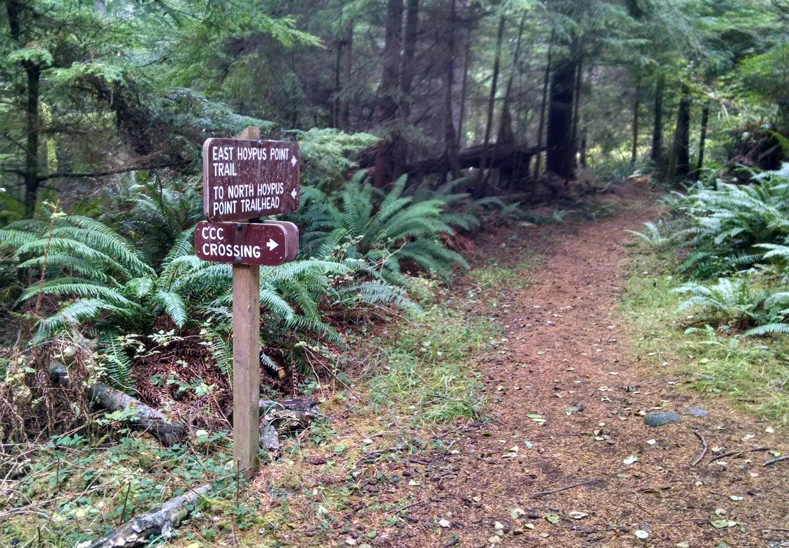
The trails are well-marked, so you can pretty much follow the signs to Goose Rock.

In fairly short order, you'll pass under the bridge.


You can head up and cross the bridge if you're ambitious from here.

Just past the bridge is a junction. It's a loop so you can go either way. I prefer the counter-clockwise direction, so head right and take the NW Summit Trail.


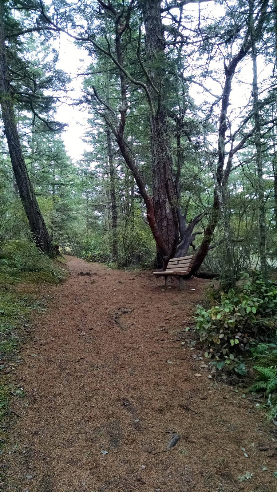
The weather was overcast and not particularly warm, but it was sure humid! This bench is not far down the trail and I stopped here to remove the jacket. I love the madrona trees next to it.


As you near the top, a helpful sign tells you a bit about the geography and reminds you that you're entering an environmentally sensitive area...


...and then you hit the power lines. I'm not against them, but it seems ironic to have the signs right before the clearing for the power lines. Just sayin'.


Remember to stay on the trail and rocks on the summit, and don't step in the meadow!


NAS Whidbey Island is nearby, and they were doing lots of practice maneuvers, so you could hear them throughout the day. They flew fairly close to the rock, too.

Planes!

I stopped at the top for lunch and watched them do touch-and-goes at the air base. There were no less than three planes in the air at any given time.

View of the island from the summit...

View
...and looking out toward the strait...

Water!
Once you're done up top, find the marked path heading east. My hiking buddy took the lead here.


The trail quickly descends with plenty of rocky switchbacks. There is a reason I prefer to go down this way.


I tried to capture the steepness in this pic, with limited success.

It's rocky and steep.
The junction at the bottom is well marked, so hang a left on the perimeter trail to begin looping back.


Two different distances, same time estimate. One trail is steeper than the other.
The trail hugs Cornet Bay, which makes for a fairly scenic stroll.


One small climb gets you over the edge of the hill here, and then it's fairly level hiking the rest of the way.

I found this rock doing its best impression of wood.


The elevation gives you a different view of the bay.


I found wood doing its best impression of fire.


You can admire the private homes on Ben Ure island. There's also a cabin you can rent there through the parks department, though it's not visible from the trail.


Ben Ure island has an interesting history. It is said that Ben Ure used the island for smuggling operations in the mid to late 1800's. His wife would signal when the coast was clear of patrol boats from nearby Strawberry Island. He was charged with possession of stolen goods. Urban legend says he was also involved with illegally smuggling Chinese immigrants. Legend says that when patrol ships were nearby, smugglers would dump their "cargo". Dead Man's Cove on San Juan Island is said to be named such because the currents would carried the bodies to that beach.

Back to the trail, you'll eventually rejoin your original trail at the bridge and can head back to the parking lot.

To add to this hike, you can take a trail parallel to North Beach to meet with Cranberry Lake and sand dunes along West Beach. You can also explore the trails on the other side of Highway 20 around Hoypus Point, or head to the other side of the bridge and explore the trails near Rosario Point and Bowman's Bay.